When you first look at a Honolulu map, it can feel like a long, glittering strip of city pinned to the ocean, but each district has its own rhythm. You might sleep in Waikīkī, shop in Ala Moana, then chase views at Diamond Head before sunset traffic hits. The trick is knowing which neighborhoods are worth your time, how to move between them without stress, and when a bus, Biki bike, rail, or car actually makes sense.
Key Takeaways
- Waikīkī and Ala Moana form the main beachfront zone, with walkable grids, calm swimming at Ala Moana Beach Park, and busiest nightlife and shopping in Waikīkī.
- Downtown and Chinatown host ʻIolani Palace, the State Capitol, historic architecture, markets, murals, and speakeasy-style nightlife in compact, easily walkable blocks.
- East toward Diamond Head, Kaimukī and Kapahulu offer local eateries, plate lunches, and access to beaches, scenic lookouts, and family-friendly parks.
- Getting around is easiest via TheBus, Skyline rail for cross-island hops, rideshare, or rental car; avoid H1 rush hour between 3–6 pm.
- Scenic drives like Tantalus, Kalanianaole Highway, and trips to Hanauma Bay or Makapuʻu require a car; check parking, fees, and reservation rules in advance.
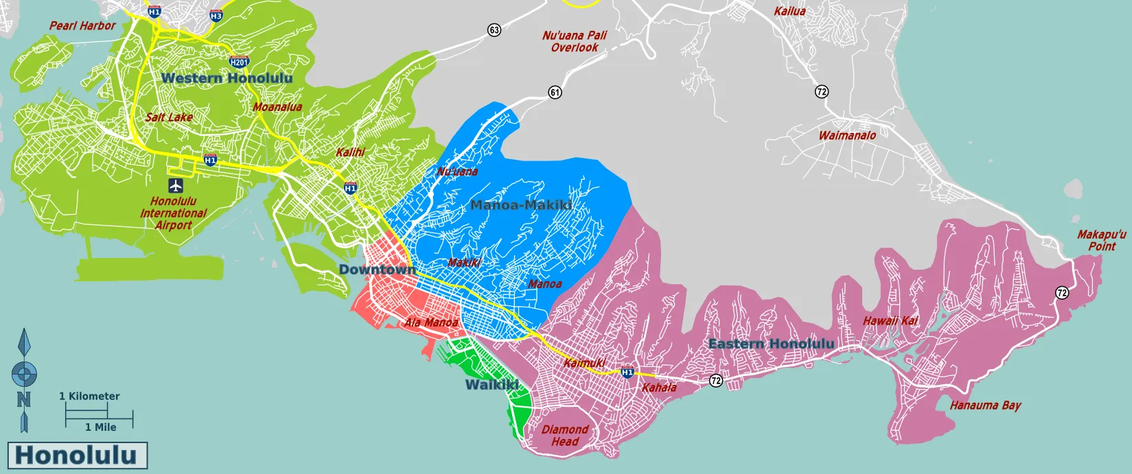
Honolulu Map Overview: Key Districts and Layout
Although Honolulu stretches farther than most visitors expect, its layout feels easy to grasp once you picture a broad curve of coast backed by green ridges.
Honolulu seems vast at first, but soon resolves into one graceful, coastal curve beneath emerald ridges
You’ll move along that arc, from older port neighborhoods to newer residential zones.
Downtown and Chinatown sit on Historic grids, so streets meet at neat angles and walking feels straightforward.
Government offices, galleries, and markets cluster here, busy on weekdays, quieter after dark.
West, the airport and industrial areas feel practical, not scenic, and you’ll mostly transit through.
East and mauka, Suburban sprawl fills the valleys, with malls, local eateries, and family beaches.
Different districts across Oahu offer distinct vacation vibes, from urban Waikiki energy to laid-back North Shore surf towns and family-friendly suburbs.
A rental car helps, though Viator tours with hotel pickup and verified reviews can link distant districts efficiently, plus free cancellation and reserve now options.
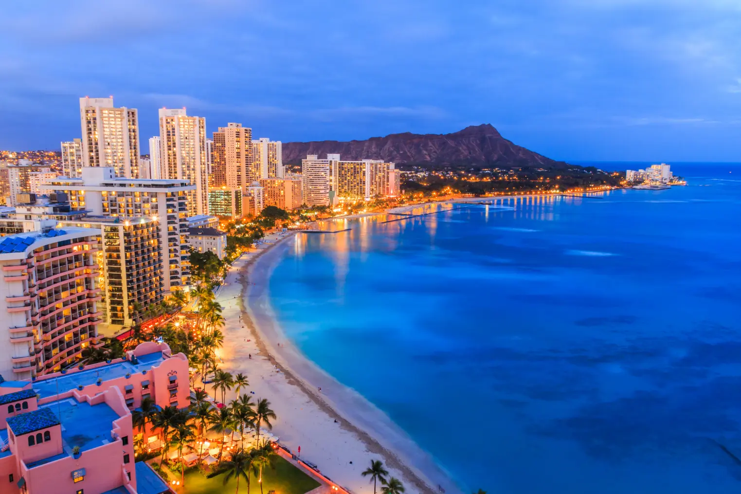
Waikīkī and Ala Moana: Beachfront Honolulu Map
From the western edge of Ala Moana to the curve of Diamond Head, this is the strip you picture when you think “Honolulu beach.” Waikīkī runs as a narrow band between the ocean and Kalākaua and Kūhiō avenues, so you’ll mostly move in a simple grid: beach on one side, hotels, bars, and shops on the other. Start at Ala Moana Beach Park for calmer swimming, then walk or bike toward Waikīkī for classic surf breaks. Early morning is best for uncrowded Surf lessons; expect around $120 for a small group. Pack reef-safe sunscreen, light rash guard, and cheap sandals you won’t miss. For Beachfront dining, time sunset at House Without A Key or a casual surf shack and skip overpriced hotel buffets. As you wander Ala Moana, you’re actually in a 119-acre historic regional park that began as reclaimed marshland in the 1920s and was dedicated in 1934 as “The Peoples Park.”
Downtown Honolulu Map: Historic and Cultural Core
Downtown is where Honolulu drops the beach towel and shows you its history.
You’ll navigate tight blocks filled with Historic landmarks, royal palaces, and civic buildings.
Start at ʻIolani Palace, then cross to the Hawaiʻi State Capitol and the statue of King Kamehameha.
ʻIolani Palace tours typically run 60–90 minutes and pair well with a stroll to nearby civic and historic sites.
Walking feels efficient; street parking is scarce and garages run about $3 to $5 per hour.
Aim for mornings to dodge heat and tour groups.
Chinatown sits just northwest, packed with markets, noodle shops, and vivid street art.
It hosts Cultural festivals like Lunar New Year that fill the lanes with drums, firecrackers, and food stalls.
Bring cash, sunscreen, and modest clothing for churches.
Skip driving between sights; a Viator walking tour with hotel pickup and verified reviews saves time overall.
Honolulu Map of Kaimukī, Kāhala, and Kapahulu
Street grids and high rises give way to homey hillsides and mellow surf as you move east into Kaimukī, Kāhala, and Kapahulu.
On the map, you’ll see three distinct zones that link easily by bus or bike.
Kaimukī’s compact blocks hide Local eateries, vintage shops, and a few pockets of Historic architecture, so slow down and walk Waialae Avenue.
Kāhala feels quieter; you’ll navigate mostly residential streets, so rideshares work better than hunting scarce parking.
Kapahulu sits closest to Waikīkī, with busy Kapahulu Avenue lined with plate lunch spots, shave ice, and surf shops. While you’re based in these eastern Honolulu neighborhoods, it’s easy to day trip to top neighborhoods across Oʻahu like Waikīkī, Ko Olina, Kailua, and the North Shore.
Expect heavy traffic around meal times.
Bring sun protection, small bills for casual cafes, and skip driving here if you’re nervous in dense, fast city traffic during weekends and holidays.
Scenic Honolulu Map: Lookouts, Ridges, and Coastal Drives
You’re ready to trade city blocks for big-sky views, and Honolulu’s map of lookouts and coastal drives makes it easy. From quick pullouts where you can snap sunrise photos in ten minutes to winding ridge roads that deserve a half-day, you’ll want to plan your route around light, traffic, and parking. Bring water, a light jacket, and a charged camera, and skip the most crowded viewpoints at peak midday if you’d rather have your ocean panoramas without a busload of selfie sticks. If you’re visiting in early summer, you can even plan your scenic drives around the lively Mango Jam Honolulu festival, turning a day of lookouts and coastal views into a full Honolulu experience.
Best Scenic Lookouts
Shake off the city grid for a while and follow Honolulu’s roads as they climb into cool ridges, cliffside lookouts, and long coastal curves.
Start with Puʻu ʻUalakaʻa State Wayside above Makiki, where you get a full sweep of Waikīkī and Pearl Harbor. Come for Sunset Photography, arrive thirty minutes early, and bring a light jacket.
Diamond Head’s summit lookout costs a small entry fee and now requires advance reservations; a Viator hiking transfer can spare you parking stress with hotel pickup, verified reviews, free cancellation, and reserve now pay later. Before you go, check current Diamond Head fees and reservation times so you don’t miss your hiking window.
For trade winds and drama, head to Nuʻuanu Pali Lookout, then finish at Makapuʻu Point, pairing its lighthouse views with short Coastal Hikes on a paved path. Carry water and skip slippery sidepaths.
Iconic Coastal Drives
After a few ridge trails and lookouts, it’s time to follow the shoreline and let the road become the scenery. Hug the coast from Waikiki to Hawaii Kai, where lava cliffs, wind-whipped palms, and sudden rainbows keep you wide awake. Use a broader Oahu map to see how these drives connect into an easy island loop.
Use your map to link these classic drives:
- Tantalus Drive and Round Top Road for sweeping city lights and late-night Coastal Photography.
- Kalanianaole Highway from Diamond Head to Makapuu for blowholes, tide pools, and quick pullouts.
- The Sunset Promenade route along Oahu’s North Shore in winter for surfers and fiery skies.
- Farrington Highway toward Kaena Point for quieter beaches and budget-friendly picnic stops.
Bring water, a light jacket, and patience. Weekend traffic can slow everything. Start early for parking and softer, less-harsh morning light.
Where to Stay in Honolulu’s Main Districts
When you choose where to stay in Honolulu, you’re really choosing how you’ll experience the city, from first-timer hotspots along Waikiki Beach to quieter family pockets near parks and calm lagoons. You can base yourself in lively areas packed with nightlife, happy hours, and late buses, or in relaxed neighborhoods where playgrounds, grocery stores, and reef-safe sunscreen are all an easy walk. As you read through the main districts, think about your budget, how late you like to stay out, and whether you’d rather wake up to city lights, soft surf, or a stroller-friendly promenade. For example, staying near the best beach areas in Waikiki puts you steps from swimmable shoreline, food streets, and the most walkable parts of Honolulu.
Best Areas For First-Timers
Before you lock in a hotel, it helps to know that “Honolulu” for first-timers usually means three main bases: buzzy Waikiki, culture-rich Downtown/Chinatown, and relaxed Ala Moana.
Waikiki puts you on the sand with easy Surf lessons at sunrise, endless shops, and quick shuttles to Pearl Harbor. It’s crowded and pricier, yet you can walk almost everywhere.
Downtown and Chinatown fit you if you want galleries, nightlife, and bold Local cuisine. Beaches sit a short bus or Biki ride away, so factor in transit time.
Ala Moana feels quieter, with a park, gentler swimming, and the island’s largest mall.
Since Honolulu sits on the island of Oahu, it helps to understand the difference between Oahu and Honolulu when planning which areas to use as your home base.
- Pick Waikiki if you’re short on time.
- Choose Downtown for urban energy.
- Base in Ala Moana for balance.
- Skip airport hotels.
Family-Friendly Neighborhood Picks
Families usually land in Honolulu with two big questions: where’s safe and easy with kids, and how close can you stay to the beach without losing your mind or budget.
For sandy mornings and calmer streets, you’ll like Waikiki’s Diamond Head side, near Kapiolani Park, where playgrounds, the zoo, and shallow sections of Kuhio Beach sit in easy walking distance.
Families also get easy access to the shaded lawns, walking paths, and open play areas of historic Kapiʻolani Regional Park, one of Oʻahu’s largest and oldest public parks.
Head inland to Manoa if you want leafy, residential calm, strong playground safety, and quick drives to supermarkets and casual noodles.
You’ll find little traffic at night and handy community centers with classes and rainy day activities.
If you prefer condos, check Ala Moana, close to Magic Island’s lagoon, big-box shopping, and frequent buses, so car‑free families manage fine.
Pack light strollers and snacks.
Top Spots For Nightlife
After sunset, Honolulu quickly shifts from beach town to neon playground, and where you stay shapes your whole night.
Base yourself in Waikiki if you want variety within walking distance. Lewers Street and Kuhio Avenue pack in casual bars, sleek Rooftop bars, and quick Late night food. Drinks run 10 to 18 dollars, so pregame a bit. For a deeper dive into Honolulu after dark, head into Downtown where speakeasies, breweries, and live music venues cluster within a few walkable blocks.
For a more local vibe, sleep near Chinatown or Kakaʻako. You can stroll to speakeasy style spots, street art, and gritty Dance clubs with strong DJs.
- Waikiki: Easy bar hopping, short walks, heavy crowds after 9 pm
- Ala Moana: Malls by day, polished hotel lounges at night
- Chinatown: Best Live music, mixed dress codes
- Kakaʻako: Creative breweries, food trucks, younger scene after midnight
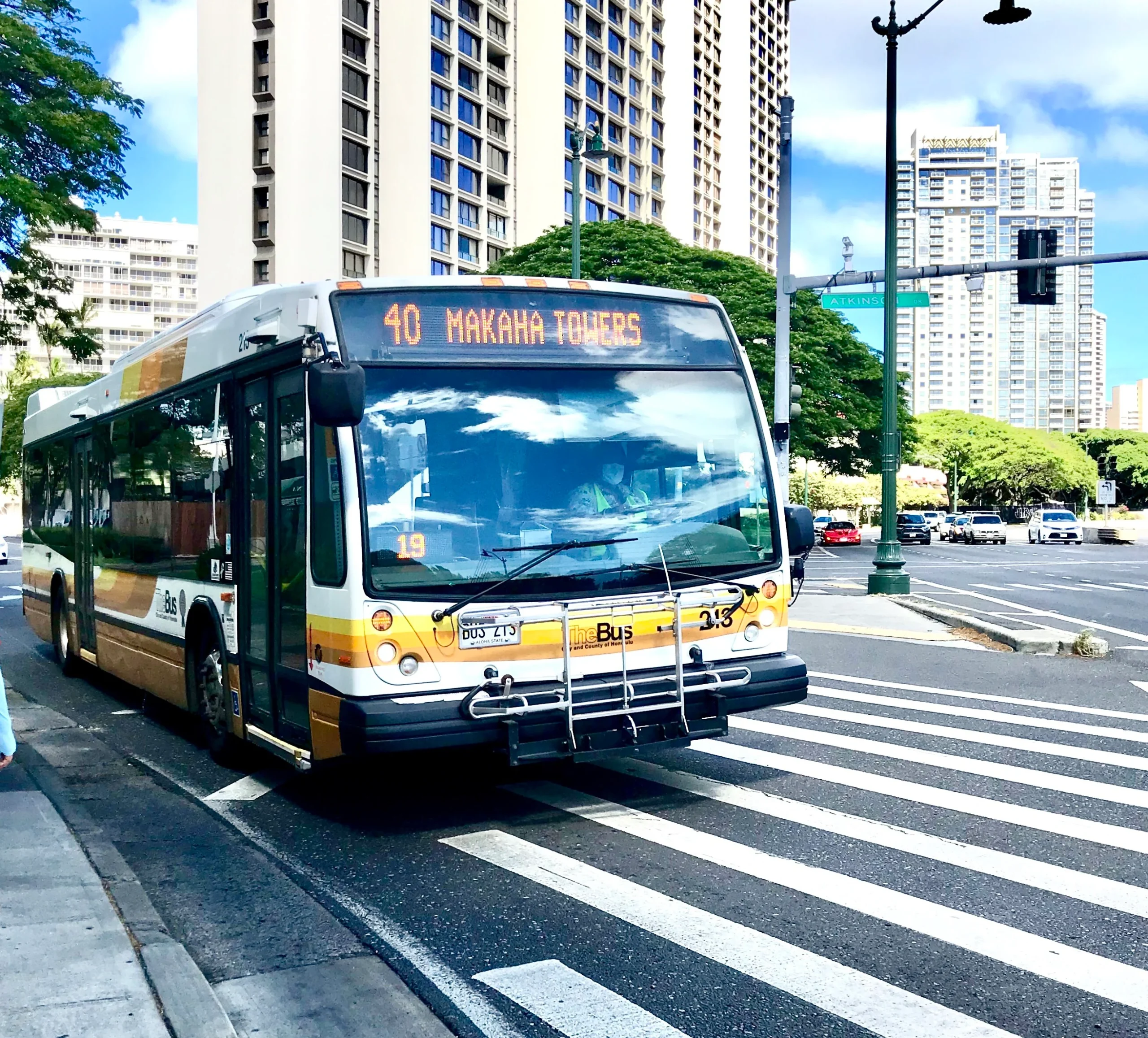
Getting Around Honolulu: Bus and Skyline Rail Map
From Waikīkī’s hotel strip to the breezy suburbs of Kapolei, Honolulu’s public transit network makes it fairly easy to move without a rental car.
You’ll rely on TheBus for most trips and the new Skyline rail for fast cross-island hops.
Bus wayfinding is simple: color maps at major stops, route numbers on poles, and a mobile trip planner that works offline if you preload it.
Fares run a few dollars, with day passes capping costs, so carry a contactless card or exact cash.
Skyline impresses with clean cars, ocean views, and strong Rail accessibility.
Elevators and level boarding help if you roll luggage or use a stroller.
Travel outside rush hour to dodge crowds.
Bring a light jacket; trains and buses can feel cool.
For stress-free rides in tourist areas, follow a simple Waikiki TheBus guide so you can spot the right routes and stops without confusion.
Driving and Parking Map for Honolulu Visitors
Slide behind the wheel in Honolulu and you’ll quickly see why locals call traffic “the other volcano.” Driving gives you freedom to chase sunrise at Hanauma Bay, shave ice in town, and sunset out in Ko Olina on your own schedule, but you’ll need a game plan for rush hour and parking. Morning and late night drives feel calmer than the 3 to 6 pm crawl on H1. Use a driving map to spot garages before you commit to a Waikiki lane. Before planning to drive up Diamond Head, check current rules and consider better alternatives like parking nearby and hiking to the summit instead.
- Expect metered parking near beaches, usually $1.50 to $3 per hour, coins or card.
- In resort zones, compare garage rates with hotel valet options.
- Watch residential signs, many tow after 6 pm.
- For Pearl Harbor and busy lookouts, arrive before 8 am.
Walking Map of Honolulu and DIY Neighborhood Tours
Step out onto Honolulu’s sidewalks and the city slows to a human pace where you can smell plumeria, hear buskers, and spot plate lunch lines before they form. For early risers, Waikiki Beach Walk offers one of the most scenic routes to catch both sunrise and sunset along the shoreline.
Grab a simple walking map or offline app, then stitch together your own DIY neighborhood tours.
Start in Waikiki for an early shoreline stroll, when paths feel quiet and shaded.
Continue into Kakaʻako for murals, coffee stops, and breezy parks.
In Downtown, try Self guided audio walks that explain royal palaces and protest marches.
Turn it into Historic plaque hunts and photograph each find.
Wear breathable clothes, reef-safe sunscreen, and light sandals or trainers.
Skip midday heat, refuel with shave ice, and keep small cash for snacks.
Even solo, you won’t feel lost with locals nearby.
Frequently Asked Questions
What Neighborhoods in Honolulu Are Best for Families With Young Children?
You’ll find the best family areas in Hawai‘i Kai, Kailua, Manoa, and Mililani, where quiet neighborhoods surround good schools, family friendly amenities, beachside parks, and safe playgrounds, so you can relax while kids explore freely.
How Safe Is Honolulu at Night in Different Districts?
You walk a patchwork kingdom: Waikiki feels lively yet guarded, Downtown demands sharper vigilance, Kapahulu and Manoa feel gentler. Study crime statistics zones, stick to lit arteries, use late night transport, and travel with caution.
Are There Honolulu Maps Highlighting Accessible Routes for Wheelchairs and Strollers?
Yes, you can find Honolulu maps that highlight wheelchair and stroller routes through city and park areas. City and sites show accessible transit, curb ramps, tactile guides, and stroller routes; you download or print them.
Which Honolulu Neighborhoods Have the Best Local Food Markets and Hole‑In‑The‑Wall Eateries?
You’ll find the best local markets and hole‑in‑the‑wall eats wandering Chinatown bites, chatting with Kakaʻako hawkers, lingering in cozy Manoa cafés, and chasing Waikīkī foodtrucks like a treasure map that keeps revealing secret dishes nightly.
How Can I Find Pet‑Friendly Areas and Parks on a Honolulu Map?
You use Google Maps or AllTrails, search “dog parks” and filter by amenities, then toggle satellite view. Check city parks websites, local Facebook groups, and pet sitters’ listings, which often highlight nearby off-leash areas too.
Conclusion
With Honolulu’s map in your head, you can stitch beaches, ridges, and markets into one easy loop. The city hosts over 4.5 million visitors a year, so plan sunrise hikes, late lunches, and off-peak buses. Pack reef-safe sunscreen, a light rain shell, and a reloadable Holo card. Skip driving at rush hour, linger in neighborhood cafés, and let the coastline, not the clock, set your schedule. Return for sunset walks, plate-lunch cravings, and island angles.
