On Oahu, you can track the island’s whole story by looking inland. The Koolau Range rises in sharp green walls, wet and folded with waterfalls, while the older Waianae Range sits drier and broader to the west, with long ridges and big sunset views. You’ll hear trade winds in one range and dry grass rustle in the other. Add a few cliffside drives and lookout stops, and the real question becomes where you go first.
Key Takeaways
- Oahu’s two main mountain ranges are the windward Koolau and the older, leeward Waianae, both formed from ancient shield volcanoes.
- The Koolau Range is steep, lush, and deeply eroded, with dramatic pali cliffs, waterfalls, and valleys shaped by heavy trade-wind rainfall.
- The Waianae Range is drier and older, with broader worn slopes, fewer streams, and Mount Kaʻala, Oahu’s highest peak at 4,003 feet.
- These ranges store and channel water through basalt, dikes, aquifers, springs, and tunnels that support much of Oahu’s water supply.
- Popular ways to explore them include Nuuanu Pali Lookout, Pali and Likelike Highways, windward beaches, and summit hikes with access checks.

Oahu: Full or Half Day Grand Circle Island Tour
Choose from two exciting ways to experience Oahu's top attractions, scenic beauty, and local culture.Option 1: Dole Plantation & Haleiwa Town (6.5 H...
What Are Oahu’s Two Mountain Ranges?
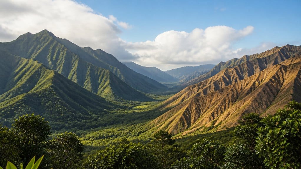
Think of Oahu as an island shaped by two giant backbones. When you look closer, you’re seeing the Koolau Range on the east and the Waianae Range on the west. Both began as huge shield volcanoes, then time, rain, and wind carved them into the island’s bold frame.
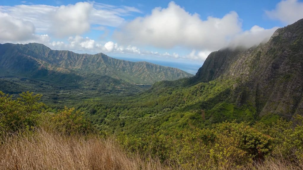
The Koolau Range runs along the windward coast for roughly 34 to 37 miles. You notice steep pali cliffs, green ridges, streams, and waterfalls fed by trade-wind rain. The Waianae Range rises on the drier leeward side. It’s older, broader in spots, and holds Mount Kaʻala, Oahu’s highest point at 4,003 feet. Together, these two mountain ranges define Oahu’s major peaks, valleys, and dramatic island skyline. In both ranges, erosion cut deep valleys with amphitheater-like heads, while hard basalt and underground dikes still shape the land and water today across the island.
Koolau vs Waianae: What’s the Difference?
Set the two ranges side by side, and Oahu’s split personality comes into focus. On the east, Koolau rises as a steep, jagged wall with serrated cliffs, wet valleys, and waterfalls fed by heavy windward rain. On the west, Waianae stands taller and older, with drier slopes, rougher ridges, and Mount Kaala topping the island at 4,003 feet.
Koolau and Waianae frame Oahu in contrasts: one lush and sheer, the other higher, older, and sunbaked.
- You’ll see Koolau’s famous pali and deeply cut amphitheater valleys.
- You’ll notice Waianae’s leeward dryness and broader, more worn terrain.
- You’ll find more streams in Koolau, while Waianae feels quieter and thirstier.
- You’ll cross the broad Central Oahu plain between them.
Together, the ranges help define Oahu’s size, shape, and the way its length, width, and area are understood. Both ranges hold permeable basalt and hidden aquifers, but Koolau’s dikes supply much of Oahu’s tunnel water. Waianae stores plenty too, just with a different rhythm underground.
How Were Oahu’s Mountain Ranges Formed?
Long before trails and lookout points, Oahu rose from the sea as two massive shield volcanoes built by layer after layer of basalt lava. As you explore the island today, you’re really seeing their worn-down cores. The older western mass became the Waianae Mountain range, where Mount Kaʻala still marks the ancient summit.
Later, Koolau Volcano swelled into a huge dome that once towered far higher than today’s ridges. Together, Waianae and Koolau answer a common question, is there a volcano in Oahu? Over time, rain, streams, and pounding surf carved deep valleys, sharp pali, and the jagged skylines you notice now. Sea levels also shifted. Some valleys drowned, filled with sediment, and left old shoreline traces above today’s coast. Even after the main building phase, smaller eruptions added tuff cones, cinder cones, and lava flows. Geology, honestly, doesn’t do boring when it builds islands.
Which Volcanoes Formed Oahu’s Ranges?
Oahu’s mountain ranges came from two giant volcanoes, and you can still read their outlines across the island today. When you look west, you’re seeing the Waianae Range, built by the older Waianae Volcano about four million years ago. Its core sat near Kolekole Pass, and Mount Kaʻala still tops the island at 4,003 feet.
- The Koolau Range came from the younger Koolau Volcano.
- Its eruptive center lay between Kaneohe and Waimanalo.
- Both volcanoes spread shield-basalt lava in smooth pahoehoe and rough aa.
- Later eruptions added cinder and tuff cones.
Together, these Oahu Hawaii mountains created the dramatic peaks and ridges that define the island’s landscape.
You can imagine these volcanoes as broad shield builders, not sharp cones. The Koolau Volcano once stood much higher than today’s ridgeline, facing the trade winds. That ancient fire shaped the bones of the island you explore now.

Oahu: Atlantis Submarine Adventure in Waikiki
Explore Waikiki’s marine mysteries while diving more than 100 feet underwater in an air-conditioned, eco-friendly...

Oahu's Circle Island Tour Operated By Fil-Am Travel & Tours
Take a tour to explore the island of Oahu as you follow along the majestic coasts with the steep mountains at your s...

Parasailing Experience in Waikiki, HI
Experience the thrill of Oahu parasailing on this unforgettable 1-hour adventure from Waikiki. Soar up to 1,000 feet...
How Did Oahu’s Valleys and Pali Form?
As you look across Oahu, you can see how rushing water carved deep valleys into the old Koolau and Waianae volcanoes, leaving steep walls and broad amphitheater heads behind. You’ll also notice the sharp pali along the coast, where heavy rain, sheer slopes, and even huge collapses like the Nuuanu landslide sliced the land into dramatic cliffs. Together, these erosion-cut valleys and striking coastal faces show you an island shaped by water, gravity, and a rough past. Nearby landmarks like Diamond Head also remind you that Oahu’s landscape includes younger volcanic features in addition to its older mountain ranges.
Erosion-Carved Valleys
If you stand at the base of a pali and look up, the cliffs feel almost unreal, rising about 500 to 2,500 feet above the valley floor in sharp, broken walls. You’re seeing erosion at work. On Oahu, heavy rain and uplift let streams cut deep into the old Koolau and Waianae volcanoes. Valleys spread from their centers toward the Windward and leeward coast, then changed again as seas rose and fell. Oahu’s landscape began forming from ancient shield volcanoes, giving the island a geologic history measured in millions of years.
- Master streams carved deep channels
- Valley heads collapsed into giant bowls
- Sea changes drowned some valley mouths
- Old strand lines sit above today’s shore
As you explore, notice amphitheater heads, steep walls, and broad valley floors. Some eastern flanks even failed and slid oceanward. It’s geology with drama, minus the ticket line. Today, rain still traces those ancient paths through ridges.
Faulted Coastal Pali
Cliffs tell the story fast. When you stand below the Koolau pali, you’re looking at volcanic slopes cut hard by rain-swollen streams and pounding surf. During the Pleistocene, erosion sliced the old shield flanks into steep, jagged walls that now rise about 500 to 2,500 feet above the coast.
You can spot big amphitheater valleys like Nuuanu and Waimanalo opening inland. Streams first carved them, then collapses, submarine erosion, and huge flank failures widened them dramatically. At times, Oahu sank more than 1,200 feet, so valley heads drowned and left strand lines now sitting roughly 100 feet above present sea level. Later, rising water dropped sediment across valley floors while coastal caprock helped lock in those sharp profiles. Diamond Head’s tuff cone, formed by explosive eruptions after Oahu’s main shield-building stage, adds a younger chapter to the island’s volcanic timeline. It’s geology with excellent timing, and excellent scenery.
Why Is the Koolau Range Greener?
When you look at the Koolau Range, you can see why it wears Oahu’s greenest coat. Trade winds hit the windward slopes, push moist air uphill, and bring heavy rain that feeds streams, waterfalls, and slick ferny ridges. You’ll notice the result fast in the lush valleys and wet cliffs, while the Waianae side looks like it forgot its water bottle. A Windward Oahu day trip is one of the easiest ways to experience those rain-fed cliffs, valleys, and coastal views up close.
Windward Rainfall Advantage
Rain is the quiet artist behind the Koolau Range’s deep green look. When you stand on the windward side, you see why. Northeast trade winds hit the Koolau Range, climb its 34-mile spine, and cool fast. That squeeze pulls moisture from the air and drops it as rain, sometimes near 300 inches yearly.
- You notice greener ridges because eastern slopes catch the wettest air.
- You feel cooler mist where steep walls hold moisture longer.
- You spot deep valleys that create sheltered, extra-humid pockets.
- You compare that with Waianae and see a drier leeward scene.
Higher summits, around 2,500 feet on average, help trap clouds. Rugged terrain keeps the dampness close. That’s why this side feels fresh, mossy, and almost polished by weather. Luckily, the mountains do the heavy lifting for you daily. For a nearby city-side perspective, Tantalus on Oahu offers lush mountain views shaped by the same island weather patterns.
Have a question about this guide?
Ask for tour ideas, hotel suggestions, or a simple trip plan that combines both.
Trip Helper
Streams And Lush Slopes
Often, the Koolau looks greener because water keeps moving through it long after the clouds pass. On Oahu’s windward side, the Koolau Range catches trade winds and turns them into heavy windward rainfall. You see the result in slick cliffs, ferny ledges, and waterfalls threading down the pali. Streams keep cutting deep valleys, then spread through lower flats where old sediments settled.
As you travel along the slopes, the ground keeps helping. Porous basalt soaks up rain, stores it, and releases it through springs, tunnels, and steady stream flow. Some shoreline caprock even slows groundwater escape, so water lingers longer than you’d expect. This steady moisture helps shape places like Kaneohe, one of the windward communities known for lush mountain views and a close connection to the Koolau slopes. That’s why the ridges stay bright and textured, with wet leaves, birdsong, and muddy shoes if you get too curious on a trail.
Where Can You See the Koolau Range Best?
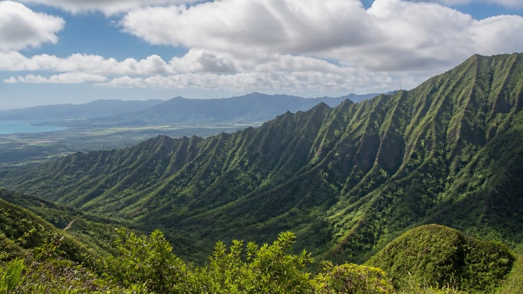
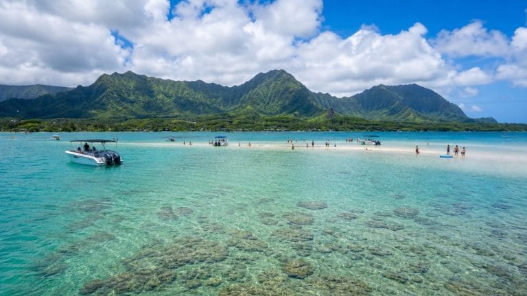
Start with the windward side if you want the Koolau Range at its most dramatic. You’ll catch sheer pali, deep valleys, and cliff faces along the Likelike and Pali highways. Those routes cross high gaps with drops that feel almost theatrical. For wider views, head to Kaneohe Bay, Kailua, or Waimanalo, where the ridges rise sharply behind the shore.
For the Koolau Range at its most dramatic, start windward: sheer pali, deep valleys, and theatrical cliffside drives.
- Drive the Pali or Likelike for cliffside views.
- Stop near Kaneohe Bay for caldera remnants.
- Look from Waikiki or Diamond Head at sunset.
- Get offshore by kayak or boat for waterfalls.
You can also admire the Koolau Range from Honolulu’s leeward side, especially near Diamond Head. If you want a closer look, choose ridge trails or roadside overlooks in the uplands. Bring a camera. The clouds love to perform here. For a quick, windy mountain stop, Nuuanu Pali Lookout offers breezy views across the Koolau cliffs and windward Oahu.
Where Can You Explore the Waianae Range?
On Oahu’s drier west side, the Waianae Range feels rougher, steeper, and a little more wild. You can start exploring from Waianae, Makaha, or Lualualei Valley, where the ridges rise fast and look almost carved from rust-colored stone. Popular trail access includes the Maili and Puu O Hulu area, plus the Nanakuli outlook. Some routes begin on a steep concrete road leading to Water Supply Pump House #2, which sounds harmless until your calves disagree.
If you want bigger goals, Mount Kaʻala towers above the range at 4,003 feet. Just check access first. Parts of the Waianae Range cross military land or restricted areas, and trail rules can change. Before you head out, plan for safe hiking by checking weather, carrying plenty of water, and telling someone your route. Bring water, solid shoes, and good judgment. Or simply admire the cliffs from Makaha, Yokohama Bay, Pokai, Mokuleia, or offshore.
Which Waterfalls and Streams Define Koolau?
Because the Koolau Range catches so much rain, water shapes nearly everything you notice there. You see streams carving steep windward valleys like Nuuanu, Manoa, and Kahana. You hear waterfalls drop off the pali, where cliffs rise 500 to 2,500 feet and turn rainfall into sudden silver ribbons. Heavy recharge keeps water moving year round, with springs and tunnel flows adding about 58 million gallons daily. Even the old lava flows matter. Their porous basalt stores perched and basal water, then releases it into the stream network. On the leeward side, Makaha Valley shows a drier contrast where Oahu’s mountain history, natural setting, and cultural stories meet.
- Watch for waterfalls spilling from sheer green walls.
- Notice broad valley floors shaped by older flooding and sediment.
- Listen for steady stream noise under forest birdsong.
- Expect wet trails, slick rocks, and muddy shoes. Nature’s souvenir, basically.

Oahu: Roundtrip Shuttle From Waikiki to Dole Plantation & Haleiwa
Skip Circle Island and visit two of the most popular places to visit here on the Island of Oahu. Experience a unique...

Oahu: Cage-Free Shark Swim on the North Shore
Experience the ultimate Oahu shark dive with this North Shore shark tour family. Swim cage‑free with sharks in the...

Honolulu: Pacific Star Sunset Dinner Cruise and Show
Indulge in the original Pacific Rim cuisine, where each dish serves as a gateway to the rich flavors of the region...
Which Drives Show Oahu’s Ranges Best?
Roads around Oahu make the ranges easy to read from behind the wheel. Start on Kalanianaole Highway from Honolulu toward Kailua and Waimanalo. For about 37 miles, the Koolau Range runs beside you with steep pali cliffs rising roughly 500 to 2,500 feet. On wetter days, waterfalls stripe the windward walls.
For a quick dramatic change, take Pali Highway and pause at Nuuanu Pali for a roadside sweep of the serrated ridge and deep valley below. Near town, the Waikiki and Diamond Head coastal drive shows younger volcanic forms tied to the Koolau Range. Then head leeward on Farrington Highway and into Lualualei Valley. You’ll see the Waianae Range turn drier, rougher, and more folded, with hints of Mount Kaala and that broad lava saddle. Together, these roads create a simple scenic driving loop that connects Oahu’s regions, beaches, and mountain views.
Which Hikes and Lookouts Are Worth It?
If you want the biggest payoff with the least effort, start at Nuuanu Pali Lookout in the Koolau Range. You’ll get huge windward views, famous cliffs, and easy access right off the highway. If you want more trail than turnout, the Koolau Range also delivers lush valley hikes with rainforest, waterfalls, and slick footing.
- Stop at Nuuanu Pali for fast views and roaring trade winds.
- Tackle Mt. Kaala in the Waianae Range for all-day summit panoramas.
- Use the Pump House #2 approach for tough ridges like Puu O Hulu.
- Keep your footing on windward trails because mud loves company.
In the Waianae Range, Mt. Kaala rewards strong legs with broad leeward vistas. For rugged drama, exposed ridges near Nanakuli Outlook feel thrilling, steep, and a little humbling. For another quick scenic stop, follow the Tantalus Lookout route when you want mountain views without a long hike. Pick your adventure, then bring water and respect.
What Beaches and Towns Sit Below the Ranges?
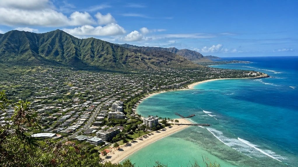
As you trace the Koolau down the windward side, you’ll spot Kaneohe, Kailua, and Waimanalo spread below sharp green cliffs, with Lanikai and Kailua Beach shining out front. Look west to the Waianae Range and you’ll find drier towns and surfy beaches like Waianae, Makaha, Pokai Bay, and Yokohama Bay, where the coast feels wilder and the road seems to run out on purpose. Around Kailua and Kaneohe, the Windward Coast also links these beach towns with some of Oahu’s most scenic coastal drives. Between the two ranges, you can picture Honolulu and Waikiki tucked along the south shore, while streams from the Koolau hurry seaward and turn the trip into a map of valleys, beaches, and everyday neighborhoods.
Windward Beaches And Towns
Often, the easiest way to read Oahu’s mountain ranges is to look at the towns and beaches spread below them. Along the windward Koolau Range, you meet a greener, rain-kissed coast where Kaneohe, Kailua, Waimanalo, and Lanikai sit between steep cliffs and bright water. Kaneohe Bay spreads wide below central valleys, sheltered by a barrier reef and backed by cloudy ridges. Kaneohe’s location on Oahu places it on the island’s windward side, just beneath the Koolau Range.
- You can trace the coast from Kaneohe to Lanikai and watch the mountains shift shape.
- You’ll notice calmer water in Kaneohe Bay and longer sandy strands in Kailua and Waimanalo.
- You can reach these towns through Nuuanu or Waimanalo pali passes from Honolulu.
- You’ll feel the windward side in damp air, rustling ironwoods, and quick passing showers.
It’s geography you can actually beach-read, with sandals on.
Leeward Coast Communities
Sun and salt define Oahu’s leeward coast below the Waianae Range, where towns like Waianae, Nanakuli, Maili, and Makaha line a drier shore of broad valleys and bright water. You feel the range pressing close behind you while eroded valleys like Lualualei and Waianae Valley open straight to the sea.
Here, you can stop at Pokai Bay for calm snorkeling, then watch stronger surf roll into Makaha Beach Park. A well-planned Waianae Coast day trip can connect these beaches and towns while leaving time for slow scenic stops. Farther north, Yokohama Bay and Mokuleia Beach Park feel wilder, with fewer buildings and more space for wind and waves. Life along this leeward coast runs on sunshine, ocean access, and tight local communities. You should know some inland ridges and parts of the western saddle stay off limits because military lands block public entry.
South Shore Below Ranges
Along Oahu’s south shore, you move through the broad space between the Koolau and Waianae ranges, where beaches, harbors, and city streets spread out below the mountains. Here, Honolulu and Waikiki sit at the foot of the Koolau Range, with Diamond Head rising near bright sand and busy surf. You can wander Ala Moana, watch boats in Honolulu Harbor, then look up at steep green pali.
- Waikiki and Kapiʻolani Park bring classic beach energy.
- Ala Moana Beach Park offers calmer water and wide lawns.
- Honolulu Harbor anchors the central coastal plain.
- Makaha, Pokai Bay, Makua, and Yokohama Bay line the Waianae Range.
On the leeward side, towns rest below the Waianae Range. West of town, the coast turns drier, quieter, and a little wilder. You’ll feel the island shift. For a different coastal contrast, the North Shore Oahu area is known for its beaches, food stops, and quick sights beyond the island’s southern plains.
What Access Rules and Permits Matter?
Before you head for a ridge or valley in the Koolau or Waianae ranges, check who manages the land because access rules change fast from one trailhead to the next. Much of both ranges borders military property, so access may stop at a fence line unless you have permission.
On state or county trails, you may need permits, parking passes, or to follow posted closures. Check DLNR and county sites before you lace up. If you join a guided ride or tour, the operator usually needs vendor permits, and larger group events may need county approval too. For the island’s western tip, plan ahead because a Kaena Point permit reservation may be required for authorized vehicle access.
Stream valleys, tunnels, and dike areas often protect water systems, so respect no-trespassing signs. From the coast, marine rules matter too. No anchoring zones can ruin your perfect plan fast.
Frequently Asked Questions
What’s the Best Time of Year to Visit Oahu’s Mountain Ranges?
You’ll get the best experience from April to October; those are the best months for drier trails, safer hikes, and clearer views. If you prefer waterfalls and lush scenery, visit in winter’s shoulder seasons despite muddier conditions.
Are Oahu’s Mountain Ranges Safe for Families With Children?
Yes, but like Icarus, you shouldn’t push limits. You’ll stay safer with child friendly trails, close supervision, plenty of water, and guided hikes. Avoid cliff edges, exposed Waianae scrambles, restricted areas, and long steep approaches.
What Should I Pack for a Day in the Koolau or Waianae?
You should pack 2–3 liters of water, sturdy hiking shoes, sun protection, a waterproof jacket, insect repellent, snacks, electrolytes, first-aid, headlamp, whistle, map or GPS, and a trash bag; bring gloves or rope for steep sections.
Can You Camp Overnight in Either Mountain Range?
Like walking a tightrope, you can’t usually camp overnight freely in either range. You must check land access, get camping permits, follow backcountry regulations, avoid military or private areas, and prepare for hazardous weather.
How Do Weather Changes Affect Mountain Visibility and Trail Conditions?
Weather changes quickly reduce what you’ll see and how safely you’ll hike: microclimate variability brings visibility degradation, fog, mud, flooding, slick ridges, loose rock, and lingering seeps, so you’ll need flexible plans and cautious footing.
Conclusion
You’ll leave Oahu’s ranges knowing the island doesn’t do subtle. Koolau throws up green walls, wet trade winds, and waterfalls that sound like applause. Waianae answers with dry ridges, long views, and Kaʻala sitting above the clouds like it owns the place. Drive the pali roads. Stop at lookouts. Check access rules before you wander off in heroic fashion. The mountains were here first, after all, and they’re still the sharpest tour guides on the island.
Oahu: Full or Half Day Grand Circle Island Tour
Choose from two exciting ways to experience Oahu's top attractions, scenic beauty, and local culture.Option 1: Dole Plantation & Haleiwa Town (6.5 H...

Oahu: Grand Tour Around Island with Snorkeling
Come join on a circle island adventure led by some of Hawaii’s most knowledgeable local guides and experience brea...

Waikiki Trolley Ocean View Blue Line
Blue Line: Sights that will take your breath away. The Blue Line is called “Coastline & Local Grindz” Line for a...

Pearl Harbor, USS Arizona Memorial & Honolulu Deluxe Coach Tour
Discover Pearl Harbor and historic Honolulu aboard a spacious Deluxe Gold Royal Star coach featuring panoramic windo...
Experiences to explore
 Explore experience ↗
Unforgettable Day on Oahu | Small Group Circle Island Tour
◷ 6 hr–7 hr
Daniels Hawaii’s mission is to provide exceptional service with ALOHA to everyone interested in tours, activities and cultural experien
See dates for Current pricing
View dates Explore experience ↗
Oahu Grand Circle Island: Discover the Heart & Soul of Hawaii
◷ 9 hr
Let us show you the wonders and beauty that makes Oahu the “Heart of Hawaii”. This complete full day tour is the perfect way to experie
See dates for Current pricing
View dates Explore experience ↗
Private Custom Island Breweries,turtles, mountain,ocean tour
◷ 5 hr
We've created a fair marketed up to 6 group size priced tour. There are 3 options. (North). North Shore, Dole pineapple, Haleiwa Town f
See dates for Current pricing
View dates