At about 597 square miles, Oahu fits like a well-packed carry-on: compact at first glance, then full of surprises once you unzip it. You can drive from city streets to windward cliffs, quiet surf towns, and red dirt trails without crossing a vast island. That size makes trip planning feel simple, yet the ridges, coastlines, and neighborhoods keep shifting the mood. The real question isn’t just how big Oahu is, but why it feels bigger once you start moving around.
Key Takeaways
- Oʻahu covers about 596.7 square miles of land, usually rounded to 597 square miles.
- It is the third-largest island in Hawaiʻi by area.
- Oʻahu is about 44 miles long from east to west.
- The island is roughly 30 miles wide from north to south.
- Oʻahu has about 227 miles of shoreline around its coast.

Oahu: Full or Half Day Grand Circle Island Tour
Choose from two exciting ways to experience Oahu's top attractions, scenic beauty, and local culture.Option 1: Dole Plantation & Haleiwa Town (6.5 H...

Small-Group Oahu Circle Island Tour with Professional Photography
During December and January, this tour begins with a sunrise viewing from a beautiful, hand-picked location, timed s...

Oahu Circle Island Tour with Waimea Valley Waterfall
Join Go Tours Hawaii as we embark on an Unforgettable Oahu Circle Island tour adventure as we journey through Hawaii...

Amazing Oahu Adventure Bundle: 6 Self-Guided Audio Tours
Shaka Guide is an audio tour app that gives you the benefits of a guided tour with the freedom to explore on your ow...
How Many Square Miles Is Oahu?
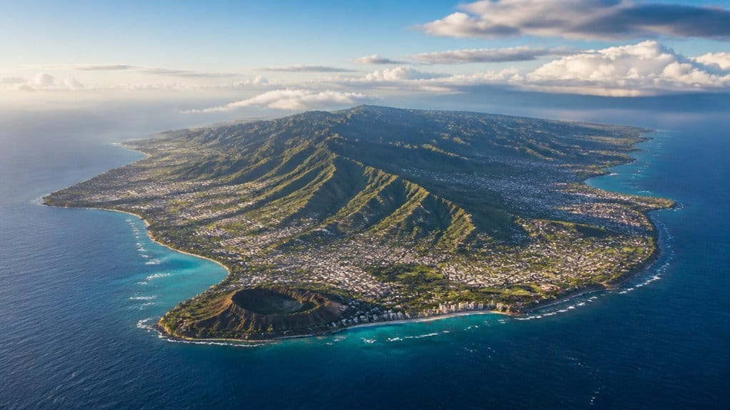
Oʻahu covers about 596.7 square miles, so when you set out to explore it, you’re looking at Hawaii’s third-largest island packed into a surprisingly manageable space. In practical terms, the Land Area is usually rounded to 597 square miles, which gives you a solid sense of the island’s footprint. These Oahu dimensions make it easier to understand how much variety fits into one island.
You can picture Oʻahu stretching about 44 miles from east to west and roughly 30 miles from north to south. This east-to-west span helps explain why the island feels easy to explore in a single trip despite its variety. That means you can drive between very different landscapes without losing a whole day. A simple scenic driving loop can help you connect major regions, beaches, and viewpoints without overcomplicating your route. One hour you’re hearing city traffic and surfboards clacking in Waikiki. Later you’re winding past green ridges, sandy coves, and roadside shrimp trucks. The island also includes about 227 miles of shoreline, so water is rarely far away. That’s a pretty sweet setup for explorers.
How Big Is Oahu Compared With Other Islands?
Put that 597-square-mile footprint next to other islands, and Oʻahu starts to feel like a sweet spot. In the Hawaiian Islands, Oahu ranks as the third-largest, so you get real room to roam without the scale feeling overwhelming. It’s smaller than the Big Island and Maui, yet larger than most of its island neighbors. As a bonus for geography-minded travelers, Honolulu is Hawaii’s capital and sits on Oʻahu, giving the island added significance beyond its size.
That balance stands out even more when you compare it with city size. You’re looking at roughly twice the land area of New York City, which surprises plenty of first-time visitors. Honolulu, the island’s urban center, is often featured in guides covering essential facts travelers should know before visiting. It’s also the island where Pearl Harbor is located, a detail many travelers look up while planning their Oahu itinerary. So when you travel around Oahu, it can feel compact on a map but generous in real life. You can move from busy Honolulu streets to quiet valleys, surf breaks, and red dirt trails without needing a full expedition team or a heroic amount of patience at all.
Oahu’s Length, Width, and Coastline
When you look at Oʻahu on a map, you can trace its east to west span at about 44 miles and its north to south width at roughly 30 miles. Honolulu sits on Oʻahu rather than being its own island, and you can spot Honolulu on a map along the south shore. You also get a better feel for the island when you picture about 227 miles of coastline, where sandy shores, sea cliffs, and surf breaks keep the edge of the island busy. Oʻahu is often called the Gathering Place, a nickname that reflects its role as Hawaiʻi’s population and cultural hub. As you travel across the middle, you’ll notice how the Waianae and Koolau ranges shape the land and give this 597 square mile island a bigger feel than you might expect. Along some of these shores, you may also spot Hawaiian monk seals, an endangered species protected under federal and state law.

Oahu Deluxe Grand Circle Island Tour
From jagged green mountains to the sparkling ocean and pristine beaches, there are plenty of stunning sites on this...

Oahu Grand Circle Island: Discover the Heart & Soul of Hawaii
Let us show you the wonders and beauty that makes Oahu the “Heart of Hawaii”. This complete full day tour is the...

Oahu Grand Circle Island Experience from Waikiki
Enjoy Grand Circle Island experience tour with breathtaking views of Amelia Earhart Lookout on Diamond Head, admire...
Island Length And Width
From tip to tip, the island stretches about 44 miles east to west and runs roughly 30 miles north to south, so it feels big enough for real variety without ever seeming endless.
On Oʻahu in the United States, you can cross surprisingly varied ground within Honolulu County. For many travelers planning a first Hawaiian island, Oʻahu’s manageable size is part of what makes it so appealing. In Honolulu, the Waikīkī Aquarium on Kalakaua Avenue offers one more easy stop that fits comfortably into an island day.
| Measure | Distance | What you notice |
|---|---|---|
| Length | 44 miles | Long day trips feel doable |
| Width | 30 miles | Mountains never seem far |
| Area | 597 sq mi | The island feels balanced |
| West range | Waianae | Rugged slopes shape the horizon |
The central saddle between Waianae and Koolau gives the island its easy-to-read form. You see broad valleys, changing weather, and neighborhoods tucked between peaks and sea. It’s compact, but it doesn’t feel small. That’s the trick. Even your drive can switch from city buzz to green ridges fast. That same compact shape is one reason full-day tours around Oʻahu can cover a lot without feeling rushed.
Total Coastline Distance
One number tells the story fast: Oʻahu packs about 227 miles of coastline into an island that’s only 44 miles long and 30 miles wide. That ratio gives you a quick feel for how much shore you can explore. For an island with about 596.7 square miles of land, that’s a lot of edge where mountains, neighborhoods, and beaches meet the sea. For many travelers, Honolulu beaches are a natural starting point for experiencing that shoreline.
As you trace the coast, you notice why the total adds up. The Koolau side curves through broad bays and rocky points. The Leeward Coast stretches into drier shores with long beach runs and bright water. Around Honolulu, Waikiki Beach stands out as one of Oʻahu’s best-known shoreline areas, with distinct swim spots and changing crowd levels along the sand. On the island’s west side, Ko Olina snorkeling is another popular way visitors experience Oʻahu’s shoreline and clear coastal water. You’re never far from salt air, trade winds, or the sound of surf. Oʻahu may rank third-largest in Hawaii, but its shoreline keeps your map looking wonderfully busy everywhere.
East To West Span
How far does Oʻahu really stretch once you picture it on the map? You’re looking at a Hawaiian island that runs about 44 miles east to west and roughly 30 miles north to south. That shape feels even more dramatic when you trace the 227 miles of shoreline around it. First-time travelers often include must-see attractions as they map out these distances across the island.
- East to west, Oʻahu spans about 44 miles.
- North to south, you get roughly 30 miles.
- Total land area covers about 596.7 square miles.
- The coastline reaches about 227 miles.
As you travel, Koolau rises on the east and Waianae stands on the west, framing the island’s long profile. Oʻahu is also known for best beaches for snorkeling, swimming, and sunsets along its varied shores. Oʻahu’s landscape was also shaped by its fiery past, with volcanic history helping form the island you see today. You can spot Diamond Head near Honolulu, then follow the windward) coast toward quieter beaches, salt air, and roads that seem to keep unfolding around every bend ahead.
Have a question about this guide?
Ask for tour ideas, hotel suggestions, or a simple trip plan that combines both.
Trip Helper
Where Oahu Is in Hawaii
You’ll find Oʻahu in the middle of the Pacific, right in the Hawaiian chain between Kauaʻi to the northwest and Molokaʻi to the southeast. That central spot helps you picture why the island feels like a natural hub, with Honolulu set along the busy southeast coast. Oʻahu is not the Big Island, which is a common point of confusion when people are learning Hawaii’s islands. Honolulu is the island’s primary city, while Oʻahu vs Honolulu is an important distinction because one is the island and the other is a city on that island. Waikiki is a Honolulu neighborhood, not a separate city, which helps clarify how this part of Oʻahu fits into the island’s geography. When you map it out, you’re not just spotting an island, you’re seeing Oʻahu hold a key place in Hawaii.
Central Pacific Position
Out in the central Pacific, Oʻahu sits near the middle of the Hawaiian chain and gives you a clear sense of where Hawaiʻi spreads across the ocean. You’re on one of the main islands, around 21.5°N and 158.0°W, with trade winds, bright water, and a real feeling of distance. Oʻahu is the third-largest island by area, so it works as a busy hub. That helps explain why places like Pearl Harbor shaped world war II history, while the North Shore shows another side. If you’re comparing seasons across the island, an Oahu weather guide can help explain how conditions differ between Honolulu and the North Shore.
Visitors staying in Honolulu often use Diamond Head transit options from Waikiki to get a better feel for Oʻahu’s southeastern coastline. For many travelers, Oahu Island Airport serves as a practical entry point before exploring different parts of the island.
- Central Pacific setting
- About 21.5°N, 158.0°W
- Third-largest Hawaiian island
- Part of Honolulu’s county government
You also stand within the State of Hawaiʻi, where Oʻahu and the Northwestern Hawaiian Islands fall under the City and County of Honolulu. It’s a practical detail, but it matters.
Between Kauai And Molokai
From that central Pacific perch, Oʻahu makes even more sense when you place it between Kauaʻi and Molokaʻi. You can picture it as the island in the middle, with the Kauaʻi Channel to the northwest and the Kaiwi Channel to the southeast. Oʻahu isn’t the largest of the Hawaiian islands. It’s the third largest, about 596.7 square miles, stretching roughly 44 miles east to west and 30 north to south. Travelers based on Oʻahu also often plan side trips using a Lanikai Beach Guide to make the most of nearby coastal experiences. For a simple North Shore outing, Haleiwa sits on Oʻahu island, making it an easy day trip from Honolulu.
| Feature | What you notice |
|---|---|
| Position | between kauai and molokai |
| Size rank | third largest |
| Channels | Kauaʻi and Kaiwi |
| Shape | 44 by 30 miles |
That spot helps you travel easily, too. You get hub energy, busy harbors, and quick flights, while ocean channels keep every neighboring island feeling just far enough away.

Oahu Small-Group Circle Island Tour with Turtle Snorkeling
Circle most of the island of Oahu on a full-day tour by minibus limited to 24 (possible to go over 28) passengers, a...

Small-Group Circle Island Tour: Snorkeling, Lunch and Admissions
Most visitors see Oahu through a bus window with 40 strangers. You'll see it differently.We cap at 13 guests, by d...

Full Day Oahu Circle Island -Turtle Beach Snorkel at North Shore
Our North Shore Circle Island Adventure including Snorkeling with the turtles offers a one-of-a-kind experience that...
How Oahu’s Mountains Shape Its Layout
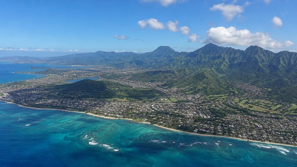
Because Oʻahu rises around two long extinct volcano ranges, the island doesn’t spread out in a simple circle. You can see how each mountain range shapes the island’s frame, with the Koolau Range on the east and the Waianae Range on the west running almost side by side. Between them, a broad central valley helps guide where roads, towns, and shorelines connect. Diamond Head tells part of that story too, since its volcanic formation adds another visible reminder of Oʻahu’s geological history. It was created by a single explosive event known as the Diamond Head eruption.
- Koolau Range runs about 34 miles from Kahuku to Makapuu.
- Its windward cliffs drop sharply near Nuuanu Pali’s famous lookout.
- Waianae Range forms the older western spine and a drier leeward side.
- Smaller cones like Koko Head and Punchbowl add extra bumps.
The Koolau Range is also known for scenic lookouts and sweeping mountain views that reveal how dramatically Oʻahu’s terrain rises and falls. As you travel, the ridges carve valleys, frame ocean views, and make Oʻahu feel folded rather than flat beneath changing skies daily.
What’s Inside Oahu’s 597 Square Miles
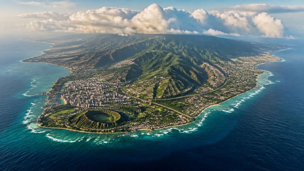
Those folded ridges hold more variety than Oʻahu’s size first suggests. Within 597 square miles, you move through an island built by two old volcanic ranges, the Waianae in the west and the Koolau in the east, with a broad middle between them. You can stand atop Kaʻala, the highest point, then trace the land down toward towns, valleys, and shore. Some visitors also set aside a day for Wet ‘n’ Wild with Waikiki transportation, adding a different kind of island experience beyond the ridgelines and beaches.
Around the edges, about 227 miles of coastline keep changing the view. You’ll find Diamond Head rising above the south shore, Waikiki beach humming with boards and footsteps, and Waimea Bay opening wide on the North Shore. Kāneʻohe Bay adds calmer water and a different color palette. Even Koko Head reminds you that Oʻahu’s famous scenery comes from fire, time, and a little patient erosion. Kailua Beach Park adds another layer with showers and bathrooms that make beach days and picnics more comfortable. Honolulu’s neighborhoods and transit also shape how visitors experience these landscapes, linking urban districts with major sights across the island.
Why Oahu Feels Bigger Than It Is
Why does Oʻahu feel bigger than a 597-square-mile island should? You notice it fast. This Gathering Place packs Honolulu and Waikīkī into one busy Head of the island, yet the rest stretches out in surprising ways. Mountains lift the horizon. Roads curve, climb, and double back, so short map distances can feel almost New York-to-suburb long. A full circle drive around Oʻahu makes that scale even clearer, because the island’s changing coasts and road patterns turn one loop into an all-day trip. Many visitors discover this most clearly on a Circle Island tour, where an 8–10 hour guided loop still only samples the island’s major coasts and lookouts.
- Kōʻolau and Waiʻanae split coasts with steep ridges.
- A 227-mile shoreline keeps revealing beaches and bays.
- Honolulu anchors most activity, so other coasts feel farther.
- Warm weather and huge crowds fill your day with stops.
You hear surf on one side and wind in ironwood on the other. You chase lookouts, towns, and coves. Some Circle Island tours even ask you to choose between snorkeling and sightseeing, which shows how much of Oʻahu can fit into a single long day without ever feeling small. Even at 596.7 square miles, Oʻahu keeps making you think there’s one more corner ahead.
What Oahu’s Size Means for Travelers
Settle into Oʻahu’s scale and your trip starts to make sense fast. At about 596.7 square miles, the island feels varied without feeling overwhelming. You can base yourself near the state capital, spend a morning in Waikīkī, then drive to the North Shore or Windward side without turning the day into a marathon.
That size also helps you group beach stops by region. You can linger in Kailua’s soft sand one day and save Ko Olina for another instead of zigzagging across the map. If you want mountains too, Oʻahu delivers. The Kōʻolau and Waiʻanae ranges create real elevation, and hikes near Koko Head crater or Manoa Falls fit neatly beside city plans. Book popular tours early, then let the island’s manageable footprint do the rest for you.
Frequently Asked Questions
How Many People Live on Oahu?
About 998,747 people live on Oʻahu in 2024. You’ll notice demographics trends show slight decline since 2020, while population density remains highest statewide. You can experience local culture most strongly around Honolulu, where residents cluster.
What Is the Best Time of Year to Visit Oahu?
Like a sweet spot, you’ll find April-May and September-October best for visiting Oahu: shoulder season brings sunshine, fewer crowds, and lower rates. Winter whale sightings tempt you, but trade wind showers increase then across much.
Do You Need a Car to Get Around Oahu?
No, you don’t need a car to get around Oʻahu if you use public transportation options, local bus routes, and ride share availability, but you’ll want one for easier access to the North Shore.
Which Side of Oahu Has the Best Beaches?
You’ll find Oʻahu’s best beaches on the Windward side if you want paradise: calm snorkeling spots, clear water, and beauty. Choose North Shore for surf, or Leeward/Waikīkī for sunshine, beach facilities, and sunset viewpoints.
How Many Days Should You Spend on Oahu?
You should spend at least 5 days on Oʻahu for a relaxed trip. You’ll enjoy local activities, day trip options, and hidden neighborhoods; if you only have 3 days, stick mostly to Honolulu, Waikīkī, and Pearl Harbor.
Conclusion
At about 597 square miles, Oahu gives you plenty to explore without turning your trip into a medieval map quest. You can start with Waikiki surf, drive past green ridges, and end on a quiet North Shore beach in the same day. The island feels varied because mountains, towns, and coasts shift fast. That compact scale helps you plan smarter, pack less stress, and spend more time hearing palms rustle, waves break, and local neighborhoods come alive.

Oahu Circle Island Tour with Byodo-In Temple Admission
This comprehensive Oahu Circle Island Tour allows you to experience the island’s most iconic sights in just one day. It is the perfect choice for fi...

Oahu's Best Circle Island Sights & Bites Tour from Waikiki
Discover why this is one of the best Oahu Circle Island tours from Waikiki. This full-day guided sightseeing and foo...

Private Tour: Ultimate Circle Island Tour of Oahu
Enjoy a private Circle Island tour tailored to your family, offering a stress-free and customizable experience. Expl...

Private Customizable Oahu Grand Circle Island Tour from Waikiki
This activity stands out for its complete flexibility and personalization—you get to design your own itinerary on...
Experiences to explore
 Explore experience ↗
Oahu Grand Circle Island: Discover the Heart & Soul of Hawaii
◷ 9 hr
Let us show you the wonders and beauty that makes Oahu the “Heart of Hawaii”. This complete full day tour is the perfect way to experie
From $139.00 USD
View dates Explore experience ↗
Discover Popoia Island and Kailua Bay by Kayak Guided Tour
◷ 3 hr
Kayak in the crystal clear waters of Kailua Bay with one of our guides and visit one of Oahu's smallest offshore islands. It's only a h
See dates for Current pricing
View dates Explore experience ↗
Snorkeling in Waikiki Many Fish All Levels Free Video & Pics!
◷ 1 hr
A great Hanauma Bay alternative right in Waikiki! If you are staying in Waikiki then most likely you will be able to walk to the snorke
See dates for Current pricing
View dates