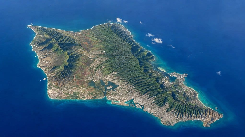
Oʻahu looks like a compass rose dropped in the Pacific, with each point pulling you toward a different kind of day. You can cross about 44 miles from Kaʻena to Makapuʻu, yet the island packs in roughly 597 square miles of cliffs, calm bays, city blocks, and red dirt trails. On the map it seems manageable. On the ground, trade winds, ridgelines, and traffic have other ideas, and that’s where the measurements start to get interesting.
Key Takeaways
- Oʻahu covers about 597 square miles, or roughly 1,545 square kilometers, making it Hawaiʻi’s third-largest main island.
- The island stretches about 44 miles east to west, from Kaʻena Point to Makapuʻu Point.
- Oʻahu is about 30 miles wide north to south at its broadest point.
- A full circle-island driving route is typically about 112 to 120 miles, depending on the exact roads taken.
- Two mountain ranges and a pinched central saddle shape Oʻahu’s dimensions and make travel feel longer than the map suggests.

Oahu Grand Circle Island Experience from Waikiki
Enjoy Grand Circle Island experience tour with breathtaking views of Amelia Earhart Lookout on Diamond Head, admire Chinaman’s Hat in front of Kualo...

Oahu: Full or Half Day Grand Circle Island Tour
Choose from two exciting ways to experience Oahu's top attractions, scenic beauty, and local culture.Option 1: Dol...

Oahu's Circle Island Tour Operated By Fil-Am Travel & Tours
Take a tour to explore the island of Oahu as you follow along the majestic coasts with the steep mountains at your s...
How Big Is Oʻahu in Miles?
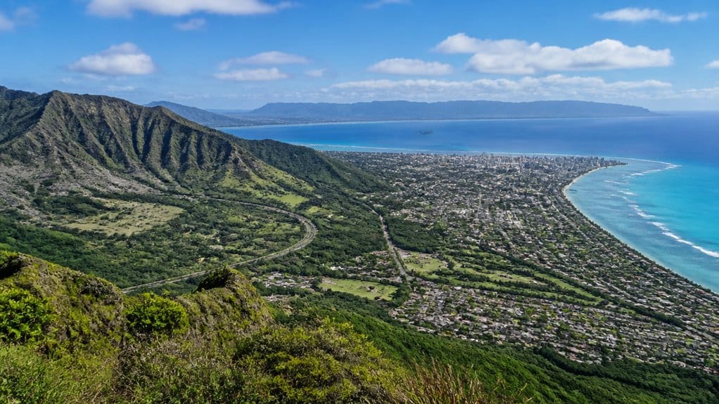
At first glance, Oʻahu feels compact, but the numbers tell a bigger story. You’re standing on a Hawaiian island with about 596.7 to 597 square miles of land, or roughly 1,545 to 1,546 square kilometers. That’s enough room for rainforests, neighborhoods, surf breaks, and ridgelines that keep changing the view.
Oʻahu’s area in square miles makes it the third-largest island in Hawaiʻi. You also feel Oʻahu’s scale along the shore. Its coastline runs about 227 miles, so beach time here can mean calm coves one hour and wave-battered cliffs the next. Then there’s the vertical surprise. Mount Kaʻala rises just over 4,000 feet above sea level, giving the island real height as well as spread. So when you explore Oʻahu, you’re not circling a tiny dot. You’re moving through a place with real range, texture, and elbow room, plus plenty of scenic detours.
Oʻahu Length, Width, and Total Area
Those big-picture numbers start to feel even more real when you map Oʻahu by length, width, and total area. You can picture the island stretching about 44 miles east to west, with a north to south width near 30 miles. Its total land area comes in at roughly 597 square miles, so you’re dealing with a compact island that still packs in serious variety.
- Length runs about 44 miles across.
- Width reaches roughly 30 miles.
- Total area is about 597 square miles.
- Coastline extends around 227 miles.
- Mount Kaʻala rises above 4,000 feet.
Knowing how many square miles Oʻahu covers helps put its beaches, mountains, cities, and rural areas into a clearer island-wide perspective. That last number matters too. Within this footprint, you get real vertical relief, not just beaches and roads. You can drive across Oʻahu, then look up and see terrain that means business, with winds, views, and quick weather shifts.
What Shape Is Oʻahu on a Map?
If you glance at Oʻahu on a map, it looks a bit like a diamond with softened corners, or even a peanut stretched from west to east. You can trace that shape by following the island’s long 44 mile span from Kaʻena Point to Makapuʻu Point. The Waiʻanae Range forms the western side. The Koʻolau Range rises along the east. Between them, a lower central saddle pinches the middle and gives Oʻahu its peanut look.
The island’s overall outline also helps with discovering Oahu’s size because its length, width, and area all connect back to those natural edges. When you zoom in, the outline gets even more interesting. The coast twists and bends instead of forming a neat edge. That’s why the shoreline runs about 227 miles. On the southeast, diamond head adds a sharp, familiar marker. Together, those ridges, curves, and tips make Oʻahu feel easy to recognize, even before you land there.
Where Oʻahu Ranks by Island Size
When you rank Hawaiʻi’s main islands by size, you’ll find Oʻahu in third place at about 597 square miles. That makes it feel compact on a map, yet at roughly 44 miles long and 30 miles across, you can still cross from surf town to city streets in a single day. Put another way, Oʻahu’s length is about 71 kilometers from end to end. You also notice the statewide contrast fast, because this mid-sized island holds about 70% of Hawaiʻi’s population.

Oahu Shark Dive on the North Shore
Book the Oahu Shark Dive for a thrilling shark encounter off the North Shore. You’ll travel by boat from Haleiwa H...

Oahu: Grand Tour Around Island with Snorkeling
Come join on a circle island adventure led by some of Hawaii’s most knowledgeable local guides and experience brea...

Oahu: North Shore Shark Cage Diving
Discover the open-ocean world of sharks on this unforgettable Oahu shark cage diving tour. More than just an adventu...
Third-Largest Island
On the Hawaiian size chart, Oʻahu lands in third place, and that rank tells you a lot about how the island feels. You get the third largest island, with an area of 597 square miles that feels substantial without seeming endless. It sits behind Hawaiʻi and Maui, yet stays larger than Kauaʻi and Molokaʻi.
- You can cross about 44 miles east to west.
- You can span roughly 30 miles north to south.
- You get about 227 miles of coastline to explore.
- You’re on land roughly twice New York City’s area.
- You notice beaches, ridges, towns, and valleys packed close.
That mix gives Oʻahu a compact, busy energy. A simple scenic driving loop can make those compact dimensions feel even more obvious as you move between regions, beaches, and inland views. You hear surf, spot green cliffs, and still reach different coasts without heroic planning or packing six snacks.
Size Compared Statewide
That third-place spot makes even more sense when you size Oʻahu up against the rest of Hawaiʻi. You’re looking at about 597 square miles of Land Area, so Oʻahu isn’t the largest of the Hawaiian islands. The Big Island and Maui outrank it. Still, Oʻahu stretches roughly 44 miles long and 30 miles wide, beating Kauaʻi and Molokaʻi. Honolulu sits on Oʻahu, which helps explain why this compact island carries so much of Hawaiʻi’s population and activity.
| What you notice | Why it matters |
|---|---|
| Third by size | You feel how compact and full it is |
| About twice NYC | You picture a surprisingly roomy island |
| Home to 70% statewide | You sense the crowds and energy |
That mix is the surprise. Kaʻala rises just over 4,000 feet, lower than Maui and Hawaiʻi peaks, yet your drive can still jump from city buzz to quiet ridges fast. That contrast stays with you.
How Long Is Oʻahu’s Coastline?
If you trace Oʻahu’s shore, you’ll usually see about 227 miles of coastline listed, though some sources shrink it to roughly 112 depending on how they measure the edge. You can thank the coastline paradox for that little puzzle, because every bay, inlet, reef, and cove adds more twists to count. For most practical planning, you’ll want the commonly used 227-mile figure as you picture the island’s beaches, harbor curves, and wave-cut corners. This coastline context also helps travelers understand Oahu’s width when comparing the island’s shore-to-shore dimensions.
Total Shoreline Length
Pinning down Oʻahu’s total shoreline is trickier than it looks, but the figure most often cited is about 227 miles, or 365 kilometers. As you trace the coast, you’re counting a shoreline that shifts from soft sand to lava rock, quiet bays, and cliffs.
- You’ll often see 227 miles listed by government and state sources.
- Some references give about 112 miles for the coast instead.
- Kāneʻohe Bay and Kailua Bay add long, curving waterfront stretches.
- Diamond Head and other volcanic headlands roughen the shoreline.
- Beaches, cliffs, reefs, and inlets all shape what you notice.
Inland landmarks such as Round Top Oahu offer another way to appreciate the island’s compact shape from above.
Still comparing Oahu Dimensions And Island Geography?
Ask for tour ideas, hotel suggestions, or a simple trip plan that combines both.
Trip Helper
Coastline Measurement Basics
While Oʻahu often gets listed at about 227 miles of coastline, that number works more like a careful estimate than a fixed fact. When you measure shoreline, the result changes with your map, your scale, and what details you count. That’s the coastline paradox in action.
You can see why on Oʻahu. The island stretches about 44 miles east to west and 30 miles north to south, yet the edge twists around points and curves in ways that add distance. Some sources list far less than 227 miles because they skip tiny tidal inlets or nearby islets. Others include every wrinkle. Standard figures usually come from U.S. mapping agencies using set methods, so you get a useful baseline, not a magic number. And to clear up a common mix-up, Oʻahu is not the Big Island; Hawaiʻi Island holds that nickname. Think ruler meets surf, with math getting sandy.
Beaches Bays And Inlets
How do you fit so much shoreline into one island? On Oʻahu, the coastline runs about 227 miles, wrapping together beaches, bays, and inlets. As you trace it, each turn feels different.
- You pass Kāneʻohe Bay, broad and calm on the windward side.
- You reach Pearl Harbor, a sheltered inlet on the south-central coast.
- You find Waikīkī, where famous beaches meet busy city energy.
- You hit Lanikai, Kailua, and Waimanalo, with pale sand and bright water.
- You round Diamond Head, Hanauma Bay, and the North Shore’s surf beaches.
You can thank the Waianae and Koʻolau ranges for much of that variety. Their old volcanic forms help shape sea cliffs, lagoons, and coastal plains. That’s why one drive can bring surf thunder, quiet coves, and soft sand between them.
Oʻahu’s Mountain Ranges and Central Valley
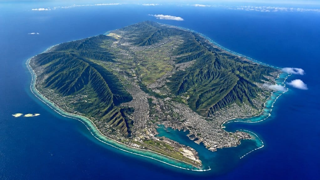
Seen from above, Oʻahu makes its shape easy to read: two old volcanic mountain ranges run along the island, with a broad central valley between them. As you cross the island, you can trace the Waiʻanae Range on the west and the Koʻolau Range on the east. They rise like long walls, shaping the island’s 44-mile length and 30-mile width.
The central valley between them feels like Oʻahu’s working corridor. You’ll find flatter land, neighborhoods, farms, and much of the Honolulu metro area there. On the windward side, the Koʻolau cliffs look sharp and deeply carved, remnants of an ancient caldera. Younger eruptions later added landmarks such as Diamond Head, whose volcanic formation helps tell the island’s more recent geological story. The leeward side turns drier and more open. Together, these parallel ranges guide rain, roads, and daily life. They don’t just frame the scenery. They organize the island, almost like nature’s blueprint.
How High Is Oʻahu From Sea Level to Kaʻala?
From the shoreline, you can trace Oʻahu’s rise all the way to Mount Kaʻala, the island’s highest point at about 4,003 to 4,025 feet above sea level. You feel that climb in the landscape, from warm coastal neighborhoods to cooler uplands and the rugged crest of the Waiʻanae Range. It’s a neat reminder that on Oʻahu, your sea-level beach day and your highest summit view aren’t all that far apart. At the island’s western tip, Kaena Point Trail highlights Oʻahu’s wild coastal beauty where land and ocean meet.

Pearl Harbor USS Arizona Memorial & Battleship Missouri
Visit USS Arizona and Battleship Missouri, as they represent both the beginning and the end of World War II. The acc...

Parasailing Experience in Waikiki, HI
Experience the thrill of Oahu parasailing on this unforgettable 1-hour adventure from Waikiki. Soar up to 1,000 feet...

Oahu: 60 Min Royal Crown Helicopter Tour - Doors Off or On
See every stunning sight on Oahu from the white sands of Waikiki to the epic big waves of Norh Shore on our incredib...
Kaʻala Peak Elevation
Climb Oʻahu to its highest point and you reach Mount Kaʻala, which rises to about 4,003 to 4,025 feet above sea level, or roughly 1,220 to 1,227 meters. From the western end of the Waiʻanae Range, you stand near the island’s Head, not its largest island neighbor, and see how Oʻahu stacks up.
- Kaʻala is Oʻahu’s highest summit.
- State and U.S. maps place it near 4,000 feet.
- Its highlands shape the island’s central watershed.
- Streams and valleys begin from these wet uplands.
- Clear days can reward you with sweeping views.
The Waiʻanae Range and the Koolau Range together define much of Oʻahu’s mountainous backbone.
From sea level to the top, you gain about 4,000 feet of relief, or 1.2 kilometers. That climb helps you feel the island’s scale in your legs, lungs, and camera roll.
Sea Level Rise
Although Oʻahu often feels like a string of beaches at sea level, the island actually rises in clear steps until it tops out at Mount Kaʻala, about 4,003 to 4,025 feet above the ocean. You see sea level rise most clearly in coastal areas, where sand, roads, and shoreline neighborhoods sit closest to trouble. Oʻahu’s dramatic relief comes from its fiery past, shaped by long-extinct volcanoes that built the island.
| Zone | Elevation |
|---|---|
| Beaches | 0–10 ft |
| Honolulu plain | Dozens to hundreds of ft |
| Central saddle | Few hundred to 1,000 ft |
Head inland and the land climbs fast. The Koʻolau and Waiʻanae ranges lift you from surf noise to cooler ridges and cloud-wrapped slopes. Between them, broad mid-elevation ground supports farms and neighborhoods. That height matters. Low shores flood first, while uplands near Kaʻala stay far above the ocean. On Oʻahu, elevation isn’t just scenery. It’s your clearest guide to risk.
How Oʻahu’s Geography Affects Climate
Because Oʻahu packs two mountain ranges, a broad central saddle, and nearly 600 square miles into one island, its weather can shift fast as you move around. Across this area, you feel the windward) coast turn lush while leeward beaches stay sunnier and drier.
- Trade winds hit Koʻolau slopes and rise.
- Rising air cools, then drops heavy rain.
- Leeward towns sit in a drier rain shadow.
- Higher ridges feel cooler than warm lowlands.
- Valleys funnel gusts and long storms inland.
Oʻahu’s main ranges, the Koʻolau and Waiʻanae mountains, help divide the island into wetter windward areas and drier leeward zones.
You notice tropical warmth near shore, usually about 70 to 85°F. Climb toward Mount Kaʻala, and the air cools as clouds thicken. Ocean water also smooths out temperature swings, so even short drives can bring surprising microclimates. On Oʻahu, sunshine and showers often ride together.
Oʻahu’s Main Regions and Distances
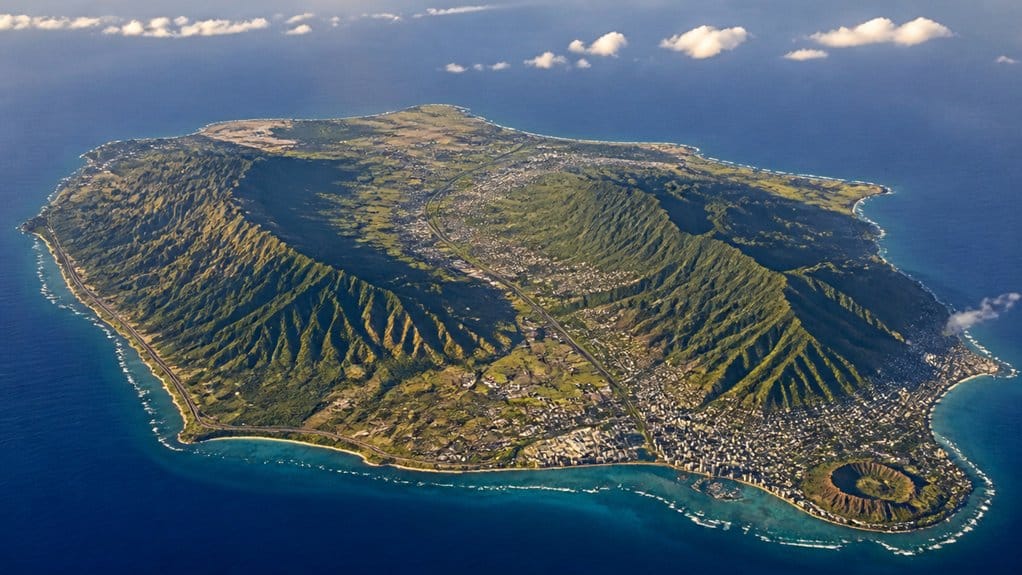
At first glance, Oʻahu looks compact on a map, yet it stretches about 44 miles from east to west and roughly 30 miles from north to south, with nearly 597 square miles packed inside its shoreline. As you trace Honolulu County, you’ll notice two mountain spines shaping everything: the Waiʻanae Range to the west and the Koʻolau Range to the east.
Between them sits a broad central plateau. To the southeast, Honolulu and Waikiki Beach form the busy urban core, where most residents live. Head northeast and you reach the Windward side, where Kāneʻohe and Kailua sit below steep green cliffs near Kāneʻohe Bay and Lanikai. Swing west and southwest and the coast turns drier around Ko Olina and Waianae. Look for Kaʻena Point, Diamond Head, and lofty Mount Kaʻala if you want Oʻahu’s geographic highlights. Around Honolulu, volcanic craters such as Diamond Head also help define the island’s dramatic southeastern landscape.
How Far Is It to Drive Across Oʻahu?
Honolulu to Haleʻiwa covers about 25 to 30 miles.
That North Shore run often takes 45 to 60 minutes.
Downtown Honolulu to Kailua is about 13 to 16 miles.
You’ll usually reach Kailua in 20 to 35 minutes.
Rush hour near Honolulu can turn easy plans into slow crawls.
A guided circle island tour often turns that loop into an 8–10 hour sightseeing day with Waikiki pickup, short scenic stops, and a North Shore lunch break.
If you loop around the island, expect roughly 112 to 120 miles on the most cited driving routes. Roll the windows down and enjoy.
Oʻahu vs. New York City in Size
Stack Oʻahu up against New York City, and the island quickly rewrites your sense of scale. You’re looking at about 597 square miles on Oʻahu versus roughly 302 in New York City, so the island is nearly twice as large by land area.
Its shape stretches too. You can trace about 44 miles east to west and roughly 30 miles north to south, far longer than New York City’s main span. Circle the island and you get about 227 miles of coastline, a long salt-rimmed loop with beaches, cliffs, and road views that keep changing. Then there’s height. Mount Kaʻala rises just over 4,000 feet, while New York stays mostly low. And even with all that room, you share Oʻahu with far fewer people than NYC overall. These dimensions also frame the island’s long story, from Ancient Hawaii through the modern Oʻahu people know today.
Why Oʻahu Feels Bigger Than It Looks
Oʻahu keeps opening up on you in ways its 597 square miles don’t suggest at first glance. You can cross only 44 miles east to west, yet a drive from Waikīkī to the North Shore can still eat an hour. Ridges, valleys, and busy streets stretch the experience.
Oʻahu feels bigger than its map suggests, with ridges, traffic, and valleys stretching every mile into something broader.
- You follow a 227-mile coastline along the Pacific.
- You pass from Waikīkī towers to quiet Windward bays fast.
- You feel Koʻolau and Waiʻanae ridges split the island into separate worlds.
- You notice rain, sun, trade winds, and lush valleys changing by the mile.
- You move through Honolulu crowds, then suddenly hear surf and chickens again.
Honolulu’s distinct neighborhoods and major sights also make short map distances feel like separate stops in a much larger place.
That mix of dense city, steep mountains, and striking shores makes Oʻahu feel less like one island and more like several chapters stitched together.
Frequently Asked Questions
How Many People Live on OʻAhu Year-Round?
You’ll find about 998,747 people living on Oʻahu year-round as of 2024. You can see demographic trends in the slight decline since 2020, while population density stays highest in and around Honolulu.
What Is the Best Time of Year to Visit OʻAhu?
You’ll love Oʻahu best from April to October, coincidentally, that’s when warm, drier weather shines. Choose shoulder months for fewer crowds and deals, or visit peak season in winter if you’re chasing North Shore surf.
Which Airport Serves Most Visitors Arriving on OʻAhu?
You’ll usually arrive through Daniel K. Inouye International Airport (HNL), which serves most visitors to Oʻahu. You can then use commuter connections, including inter-island flights, shuttles, buses, taxis, and rentals, to reach your destination quickly.
What Are OʻAhu’s Most Popular Beaches for Swimming?
You’ll love Waikīkī for calm swims, Lanikai for clear water, Kailua for easy family fun, Hanauma Bay for reef-filled snorkeling, and Ko Olina for sheltered lagoons, plus Waikiki Surfing and Lanikai Snorkeling round out favorites.
Do You Need a Rental Car to Explore OʻAhu?
You don’t always need a rental car on Oʻahu; it depends on your plans. Stay in Waikīkī, use rental alternatives and transit tips. For North Shore, hikes, or remote beaches, you’ll save time with a car.
Conclusion
At just 44 miles long, Oʻahu proves size can be delightfully misleading. You can drive from surf-heavy Kaʻena to wind-whipped Makapuʻu in a day, yet the island keeps changing under your wheels. One minute you hear city traffic in Honolulu. Next you’re in red dirt, ironwood shade, and rooster soundtrack country. That 4,000-foot rise to Mount Kaʻala helps explain the magic. On Oʻahu, short distances hold whole worlds, and your map never tells the full story.
Oahu Grand Circle Island Experience from Waikiki
Enjoy Grand Circle Island experience tour with breathtaking views of Amelia Earhart Lookout on Diamond Head, admire Chinaman’s Hat in front of Kualo...

Oahu Majestic Circle Island Tour with Waimea Falls and Byodo Inn
Since 1974, E Noa Tours has specialized in showing visitors the real Oʻahu through immersive experiences led by pas...
Oahu: Full or Half Day Grand Circle Island Tour
Choose from two exciting ways to experience Oahu's top attractions, scenic beauty, and local culture.Option 1: Dol...
Oahu's Circle Island Tour Operated By Fil-Am Travel & Tours
Take a tour to explore the island of Oahu as you follow along the majestic coasts with the steep mountains at your s...